Презентация Nелекоммуникационнsq проект «Travelling around Northern Ireland» онлайн
На нашем сайте вы можете скачать и просмотреть онлайн доклад-презентацию на тему Nелекоммуникационнsq проект «Travelling around Northern Ireland» абсолютно бесплатно. Урок-презентация на эту тему содержит всего 24 слайда. Все материалы созданы в программе PowerPoint и имеют формат ppt или же pptx. Материалы и темы для презентаций взяты из открытых источников и загружены их авторами, за качество и достоверность информации в них администрация сайта не отвечает, все права принадлежат их создателям. Если вы нашли то, что искали, отблагодарите авторов - поделитесь ссылкой в социальных сетях, а наш сайт добавьте в закладки.
Оцените презентацию от 1 до 5 баллов!
- Тип файла:ppt / pptx (powerpoint)
- Всего слайдов:24 слайда
- Для класса:1,2,3,4,5,6,7,8,9,10,11
- Размер файла:343.00 kB
- Просмотров:114
- Скачиваний:1
- Автор:неизвестен
Слайды и текст к этой презентации:
№1 слайд
Содержание слайда:
№2 слайд

Содержание слайда:
№3 слайд
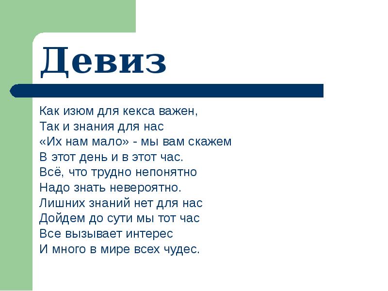
Содержание слайда: Как изюм для кекса важен,
Как изюм для кекса важен,
Так и знания для нас
«Их нам мало» - мы вам скажем
В этот день и в этот час.
Всё, что трудно непонятно
Надо знать невероятно.
Лишних знаний нет для нас
Дойдем до сути мы тот час
Все вызывает интерес
И много в мире всех чудес.
№4 слайд

Содержание слайда: English_2_КЕКС_Русская_Поляна
Команда Русскополянской школы №2
Этап II - Составьте опорные схемы по прочитанным текстам
№5 слайд
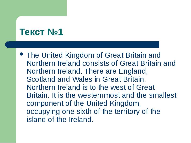
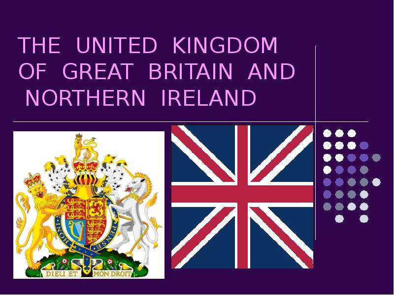
Содержание слайда: The United Kingdom of Great Britain and Northern Ireland consists of Great Britain and Northern Ireland. There are England, Scotland and Wales in Great Britain. Northern Ireland is to the west of Great Britain. It is the westernmost and the smallest component of the United Kingdom, occupying one sixth of the territory of the island of the Ireland.
The United Kingdom of Great Britain and Northern Ireland consists of Great Britain and Northern Ireland. There are England, Scotland and Wales in Great Britain. Northern Ireland is to the west of Great Britain. It is the westernmost and the smallest component of the United Kingdom, occupying one sixth of the territory of the island of the Ireland.
№6 слайд

Содержание слайда:
№7 слайд
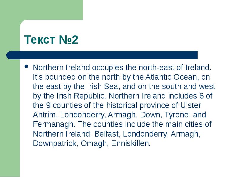
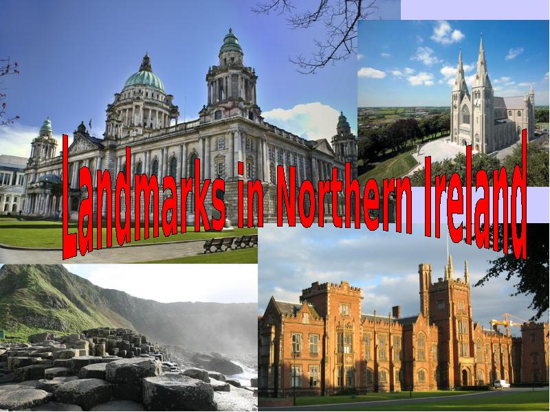
Содержание слайда: Northern Ireland occupies the north-east of Ireland. It's bounded on the north by the Atlantic Ocean, on the east by the Irish Sea, and on the south and west by the Irish Republic. Northern Ireland includes 6 of the 9 counties of the historical province of Ulster Antrim, Londonderry, Armagh, Down, Tyrone, and Fermanagh. The counties include the main cities of Northern Ireland: Belfast, Londonderry, Armagh, Downpatrick, Omagh, Enniskillen.
Northern Ireland occupies the north-east of Ireland. It's bounded on the north by the Atlantic Ocean, on the east by the Irish Sea, and on the south and west by the Irish Republic. Northern Ireland includes 6 of the 9 counties of the historical province of Ulster Antrim, Londonderry, Armagh, Down, Tyrone, and Fermanagh. The counties include the main cities of Northern Ireland: Belfast, Londonderry, Armagh, Downpatrick, Omagh, Enniskillen.
№8 слайд

Содержание слайда:
№9 слайд
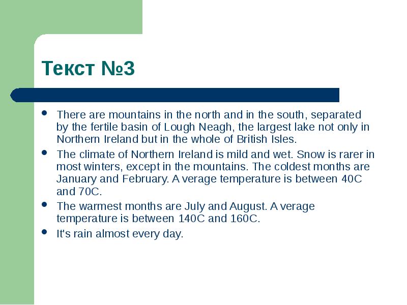
Содержание слайда: There are mountains in the north and in the south, separated by the fertile basin of Lough Neagh, the largest lake not only in Northern Ireland but in the whole of British Isles.
There are mountains in the north and in the south, separated by the fertile basin of Lough Neagh, the largest lake not only in Northern Ireland but in the whole of British Isles.
The climate of Northern Ireland is mild and wet. Snow is rarer in most winters, except in the mountains. The coldest months are January and February. A verage temperature is between 40C and 70C.
The warmest months are July and August. A verage temperature is between 140C and 160C.
It's rain almost every day.
№10 слайд

Содержание слайда:
№11 слайд
Содержание слайда: Ответьте на вопросы:
Ответьте на вопросы:
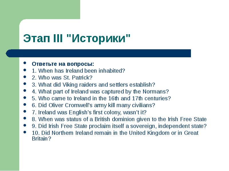
1. When has Ireland been inhabited?
2. Who was St. Patrick?
3. What did Viking raiders and settlers establish?
4. What part of Ireland was captured by the Normans?
5. Who came to Ireland in the 16th and 17th centuries?
6. Did Oliver Cromwell's army kill many civilians?
7. Ireland was English's first colony, wasn't it?
8. When was status of a British dominion given to the Irish Free State
9. Did Irish Free State proclaim itself a sovereign, independent state?
10. Did Northern Ireland remain in the United Kingdom or in Great Britain?
№12 слайд

Содержание слайда: 1. Most of Ireland was covered with ice until the end of the last ice age over 9,000 years ago. Sea-levels were lower and Ireland was a part of continental Europe rather than being islands. Mesolithic stone Аge inhabitants arrived some time after 8,000 BC
1. Most of Ireland was covered with ice until the end of the last ice age over 9,000 years ago. Sea-levels were lower and Ireland was a part of continental Europe rather than being islands. Mesolithic stone Аge inhabitants arrived some time after 8,000 BC
2. The Chronicle of Ireland records that in 431 AD Bishop Palladius arrived in Ireland on a mission from Pope Celestine I to minister to the Irish "already believing in Christ." The same chronicle records that Saint Patrick, Ireland's patron saint, arrived the following year. There is continued debate over the missions of Palladius and Patrick but consensus that they both took place and certainty that the older druid tradition collapsed in the face of the new religion.
3. From the 9th century, waves of Viking raiders plundered Irish monasteries and towns. These raids added to a pattern of raiding and endemic warfare that was already deep seeded in Ireland.
№13 слайд

Содержание слайда: 4. The Norman invasion of Ireland began on 1 May 1169 when a Norman military force landed near Bannow, County Wexford. This was at the behest of Dermot MacMurrough (Diarmait Mac Murchada), the ousted King of Leinster who sought their help in regaining his kingdom.
4. The Norman invasion of Ireland began on 1 May 1169 when a Norman military force landed near Bannow, County Wexford. This was at the behest of Dermot MacMurrough (Diarmait Mac Murchada), the ousted King of Leinster who sought their help in regaining his kingdom.
On 18 October 1171, Henry II landed a much bigger force in the same area. Much of the island was conquered and became the "Lordship of Ireland", which formed part of the Angevin Empire.
5. Ireland during the period 1536–1691 saw the first full conquest of the island by England and its colonization with Protestant settlers from Britain.
6. Yes, it did. 200,000 civilians died as a result of a combination of war related famine, displacement, guerilla activity and pestilence over the duration of the war. A further 16,000 were tried and sent to slavery in the West Indies. Some historians estimate that as much as half of the pre-war population of Ireland may have died as a result of the conflict.
7. Yes, it was.
№14 слайд
Содержание слайда: 8. In July 1921, a cease-fire was agreed and negotiations between delegations of the Irish and British sides produced the Anglo-Irish Treaty. Under the treaty, southern and western Ireland was to be given a form of dominion status.
8. In July 1921, a cease-fire was agreed and negotiations between delegations of the Irish and British sides produced the Anglo-Irish Treaty. Under the treaty, southern and western Ireland was to be given a form of dominion status.
9. In 1921, the Anglo-Irish Treaty was concluded between the British Government giving Ireland complete independence towards their home affairs and practical independence for foreign policy however an oath of allegiance to the British Crown had to be exercised.
10. Northern Ireland remained in the United Kingdom.
№15 слайд
Содержание слайда: "Графства Северной Ирландии"
"Графства Северной Ирландии"
Where is the country situated?
What is it famous for?
№16 слайд
Содержание слайда: Londonderry and it is washed by the Irish Sea.The international air-port Belfast of Ireland is located in this county. It is the main air-port of Northern Ireland. There are also two main ports Larn and Belfast there. The operator of Translink is provided by a report between cities through the Northirish railway. The main natural sight of this county is "The Path of Giant".
Londonderry and it is washed by the Irish Sea.The international air-port Belfast of Ireland is located in this county. It is the main air-port of Northern Ireland. There are also two main ports Larn and Belfast there. The operator of Translink is provided by a report between cities through the Northirish railway. The main natural sight of this county is "The Path of Giant".
№17 слайд
Содержание слайда: Geographically the country is located between Lough Neagh - the greatest lake of Ireland, the lake Lough Foule, the river Bann and the Sperrin mountains.The most known sights of county are the city Derry (70.000 habitants) with its historical city wall, town hall, working quarter and towers of English soldiers, the city Coleraine (57.000 habitants), the eldest settlement in the county. Also one of the brightest sight of the city is the Saint Patrick’ church. The county is considered the capital of Helloween in Ireland.
Geographically the country is located between Lough Neagh - the greatest lake of Ireland, the lake Lough Foule, the river Bann and the Sperrin mountains.The most known sights of county are the city Derry (70.000 habitants) with its historical city wall, town hall, working quarter and towers of English soldiers, the city Coleraine (57.000 habitants), the eldest settlement in the county. Also one of the brightest sight of the city is the Saint Patrick’ church. The county is considered the capital of Helloween in Ireland.
№18 слайд
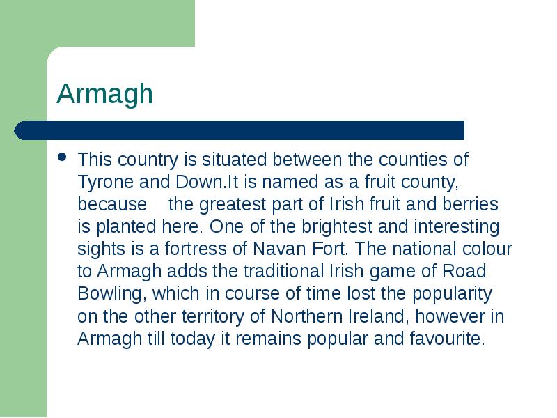
Содержание слайда: This country is situated between the counties of Tyrone and Down.It is named as a fruit county, because the greatest part of Irish fruit and berries is planted here. One of the brightest and interesting sights is a fortress of Navan Fort. The national colour to Armagh adds the traditional Irish game of Road Bowling, which in course of time lost the popularity on the other territory of Northern Ireland, however in Armagh till today it remains popular and favourite.
This country is situated between the counties of Tyrone and Down.It is named as a fruit county, because the greatest part of Irish fruit and berries is planted here. One of the brightest and interesting sights is a fortress of Navan Fort. The national colour to Armagh adds the traditional Irish game of Road Bowling, which in course of time lost the popularity on the other territory of Northern Ireland, however in Armagh till today it remains popular and favourite.
№19 слайд

Содержание слайда: It is located between the lake of Carlingford, the river Bann, the lake Belfast and the Irish Sea. The monuments of history of Stone Age were saved in the county. They behave to buildings of Megalith. The tombs are located in this county (Court tombs, Passage tombs, Portal tombs and Wedge tombs), which were completed in early Bronze Age.
It is located between the lake of Carlingford, the river Bann, the lake Belfast and the Irish Sea. The monuments of history of Stone Age were saved in the county. They behave to buildings of Megalith. The tombs are located in this county (Court tombs, Passage tombs, Portal tombs and Wedge tombs), which were completed in early Bronze Age.
№20 слайд
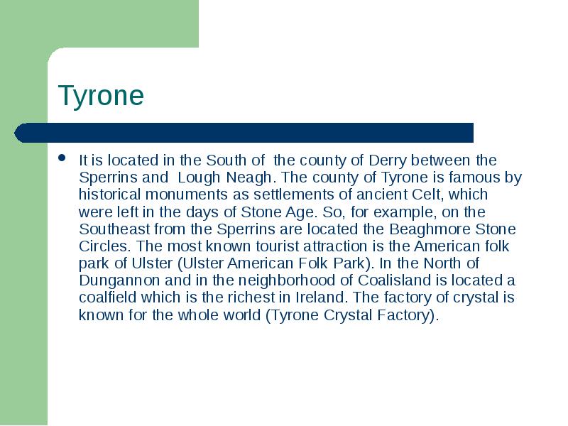
Содержание слайда: It is located in the South of the county of Derry between the Sperrins and Lough Neagh. The county of Tyrone is famous by historical monuments as settlements of ancient Celt, which were left in the days of Stone Age. So, for example, on the Southeast from the Sperrins are located the Beaghmore Stone Circles. The most known tourist attraction is the American folk park of Ulster (Ulster American Folk Park). In the North of Dungannon and in the neighborhood of Coalisland is located a coalfield which is the richest in Ireland. The factory of crystal is known for the whole world (Tyrone Crystal Factory).
It is located in the South of the county of Derry between the Sperrins and Lough Neagh. The county of Tyrone is famous by historical monuments as settlements of ancient Celt, which were left in the days of Stone Age. So, for example, on the Southeast from the Sperrins are located the Beaghmore Stone Circles. The most known tourist attraction is the American folk park of Ulster (Ulster American Folk Park). In the North of Dungannon and in the neighborhood of Coalisland is located a coalfield which is the richest in Ireland. The factory of crystal is known for the whole world (Tyrone Crystal Factory).
№21 слайд
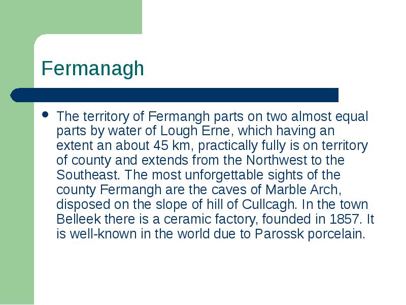
Содержание слайда: The territory of Fermangh parts on two almost equal parts by water of Lough Erne, which having an extent an about 45 km, practically fully is on territory of county and extends from the Northwest to the Southeast. The most unforgettable sights of the county Fermangh are the caves of Marble Arch, disposed on the slope of hill of Cullcagh. In the town Belleek there is a ceramic factory, founded in 1857. It is well-known in the world due to Parossk porcelain.
The territory of Fermangh parts on two almost equal parts by water of Lough Erne, which having an extent an about 45 km, practically fully is on territory of county and extends from the Northwest to the Southeast. The most unforgettable sights of the county Fermangh are the caves of Marble Arch, disposed on the slope of hill of Cullcagh. In the town Belleek there is a ceramic factory, founded in 1857. It is well-known in the world due to Parossk porcelain.
№22 слайд
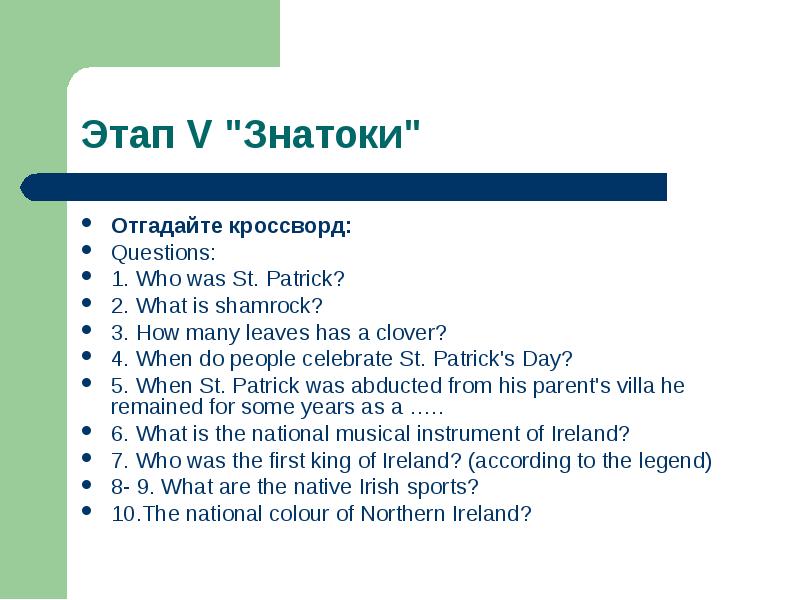
Содержание слайда: Отгадайте кроссворд:
Отгадайте кроссворд:
Questions:
1. Who was St. Patrick?
2. What is shamrock?
3. How many leaves has a clover?
4. When do people celebrate St. Patrick's Day?
5. When St. Patrick was abducted from his parent's villa he remained for some years as a …..
6. What is the national musical instrument of Ireland?
7. Who was the first king of Ireland? (according to the legend)
8- 9. What are the native Irish sports?
10.The national colour of Northern Ireland?
№23 слайд

Содержание слайда:
№24 слайд

Содержание слайда:
Скачать все slide презентации Nелекоммуникационнsq проект «Travelling around Northern Ireland» одним архивом: